Solis Announces: Drilling Commenced at Ilo Este Copper Gold Project, Peru
Solis Minerals starts 5,000m drilling at Ilo Este, Peru, testing copper-gold targets in a prolific district with promising historical results and new exploration data.

Michael Chen
Senior Mining Analyst
HIGHLIGHTS
Drilling has commenced at Solis Minerals' flagship Ilo Este copper-gold project in Peru.
Initial program to comprise approximately 5,000 metres of diamond drilling.
Program designed to test areas of known copper-gold mineralisation and evaluate new target zones identified through recent geophysical and geological work.
Ilo Este is located in a world-class mining district, near several major copper mines and excellent infrastructure.
West Leederville, Western Australia--(Newsfile Corp. - August 11, 2025) - Solis Minerals Limited (ASX: SLM) ("Solis Minerals" or the "Company") is pleased to announce that diamond drilling has commenced at its flagship project, the Ilo Este copper-gold Project in southern Peru (Figure 1). Ilo Este is 100%-owned by Solis Minerals.
The initial diamond drilling program will comprise approximately 5,000 metres and is designed to follow up on historical intercepts of broad porphyry-style copper-gold mineralisation1. Drilling has commenced in the north-east of the Ilo Este project area targeting a northern magnetic anomaly before mobilising to the southern magnetic anomaly (Figure 2). The program will also test newly defined targets generated through recent mapping, surface sampling and reinterpretation of historical geophysics2.
The Ilo Este project is located in a prolific copper district that hosts several major international copper mining companies in production or with advanced projects including Southern Copper, Teck and Anglo American. The Company's targets (Figure 2) are analogous to AusQuest Limited's (ASX: AQD) Cangallo exploration prospect in southern Peru, where wide zones of copper mineralisation have been discovered3.
Chief Executive Officer, Mitch Thomas, commented:
"We are very excited to commence drilling at Ilo Este. This project represents a compelling exploration opportunity in a highly prospective geological setting.
The existence of historical drilling, including YAR0014 with an intersection of 158 metres @ 0.20% copper and 0.16 g/t gold from surface5 and IE-DDH-005-15 with an intersection of 291 metres @ 0.21 g/t gold from 102 metres, highlight the attractive prospectivity of the Ilo Este project. Technical studies completed over the past 24 months have identified additional untested attractive targets.
Our team has worked diligently to refine a five thousand metre work programme and secure all necessary approvals, and we look forward to updating shareholders as results become available."
1 Refer to ASX: SLM announcement from 22 April 2025 Corporate Presentation. Refer to ASX: LRS announcement from 29 April 2014 Latin Defines Significant Copper-Gold Porphyry System at Ilo Este With Multiple Drill Targets.
2 Refer to ASX: SLM announcement from 13 December 2023 Anomaly confirms drill target zone during IP study at Ilo Este.
3 Refer to ASX: AQD announcement from 21 July 2025 Cangallo porphyry copper discovery grows.
4 Refer to the Note at end of this release.
5 Please refer to the note commencing on page four in relation to non-JORC compliant historical exploration results.
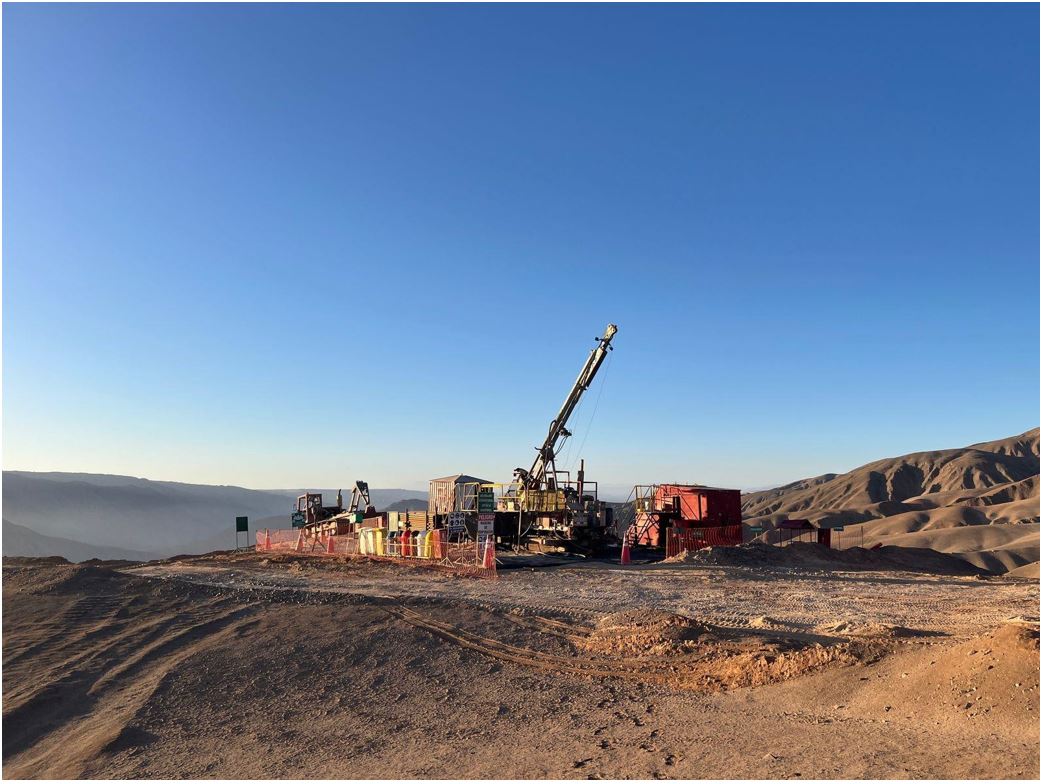
Figure 1: Diamond drill rig operating at Ilo Este, Peru. Hole ID: P-15
To view an enhanced version of this graphic, please visit:
https://images.newsfilecorp.com/files/1134/262022_solis1.jpg
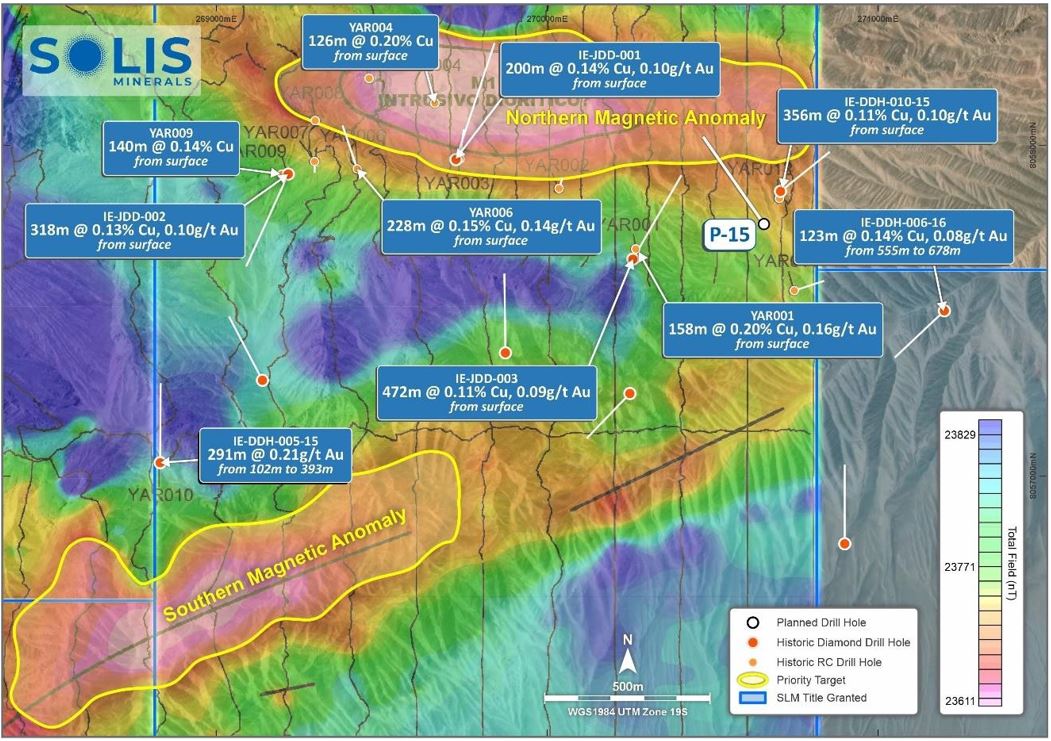
Figure 2: Ilo Este, Peru concession area showing location of drill hole one (P-15) targeting the northern magnetic anomaly labelled. Please refer to the Note on page four in relation to non-JORC compliant historical exploration results.
To view an enhanced version of this graphic, please visit:
https://images.newsfilecorp.com/files/1134/262022_solis2.jpg
ENDS
This announcement is authorised for release by the Board of Solis Minerals Ltd.
| Contact | Media & Broker Enquiries: |
| Mitch Thomas Chief Executive Officer Solis Minerals Limited +61 458 890 355 | Fiona Marshall White Noise Communications [email protected] +61 400 512 109 |
About Solis Minerals Limited
Solis Minerals is an emerging exploration company, focused on unlocking the potential of its South American copper portfolio. The Company is building a significant copper portfolio around its core tenements of Ilo Este and Ilo Norte and elsewhere in the Southern Coastal Belt of Peru.
The Company is led by a highly-credentialled and proven team with excellent experience across the mining lifecycle in South America. Solis Minerals is actively considering a range of copper opportunities. South America is a key player in the global export market for copper and Solis Minerals, under its leadership team, is strategically positioned to capitalise on growth the opportunities within this mineral-rich region.
Forward-Looking Statements
This news release contains certain forward-looking statements that relate to future events or performance and reflect management's current expectations and assumptions. Such forward- looking statements reflect management's current beliefs and are based on assumptions made and information currently available to the Company. Readers are cautioned that these forward-looking statements are neither promises nor guarantees and are subject to risks and uncertainties that may cause future results to differ materially from those expected, including, but not limited to, market conditions, availability of financing, actual results of the Company's exploration and other activities, environmental risks, future metal prices, operating risks, accidents, labour issues, delays in obtaining governmental approvals and permits, and other risks in the mining industry. All the forward-looking statements made in this news release are qualified by these cautionary statements and those in our continuous disclosure filings. These forward-looking statements are made as of the date hereof, and the Company does not assume any obligation to update or revise them to reflect new events or circumstances save as required by applicable law.
Qualified Person Statement
The technical information in this news release was reviewed by Michael Parker, a Fellow of the Australian institute of Mining and Metallurgy (AusIMM), a qualified person as defined by National Instrument 43-101 (NI 43-101). Michael Parker is Technical Director of the Company.
Competent Person Statement
The information in this ASX release concerning Geological Information and Exploration Results is based on and fairly represents information compiled by Mr Michael Parker, a Competent Person who is a Fellow of the Australasian Institute of Mining and Metallurgy. Mr Parker is a contractor to Solis Minerals Ltd. and has sufficient experience which is relevant to the style of mineralisation and types of deposit under consideration and to the exploration activities undertaken to qualify as a Competent Person as defined in the 2012 Edition of the "Australian Code for Reporting of Mineral Resources and Ore Reserves". Mr Parker consents to the inclusion in this report of the matters based on information in the form and context in which it appears. Mr Parker has provided his prior written consent regarding the form and context in which the Geological Information and Exploration Results and supporting information are presented in this Announcement.
Disclaimer
In relying on the above mentioned ASX announcement and pursuant to ASX Listing Rule 5.23.2, the Company confirms that it is not aware of any new information or data that materially affects the information included in the above-mentioned announcement.
Note:
Some of the historical Exploration Results above have been previously reported by Latin Resources Limited as noted in the footnotes. Due to historical data recently being sourced from digital archives, additional drillhole data from Rio Tinto Limited ("Rio Tinto") has been presented that has not been previously reported.
As noted, some historic exploration was undertaken and reported in the 2000's. Specifically, drilling was completed by Rio Tinto Exploration in the year 2000, and Latin Resources and its JV partner Zahena between 2014 and 2016. No results from the Rio Tinto drilling have been located in the public domain.
Solis is unable to determine the accuracy of all drilling results from Rio Tinto, however Solis is of the opinion that drilling undertaken in 2000 should be reliable under current standards. Rio Tinto completed 12 RC holes for a total of 2,128 metres of varying depths. All RC collars have been located and verified by Solis personnel in the field, including the QP.
Solis has not identified any additional exploration results or data relevant to understanding these Exploration Results.
Solis Minerals intends to complete several diamond drillholes in proximity to prior exploration by Rio Tinto to, where possible, validate the historic results noted above. Detailed hole location surveys will be completed for new holes undertaken by Solis and will include historical collars.. All new activities undertaken by Solis will be reported in accordance with the JORC Code 2012.
Solis intends to undertake the proposed exploration work in the second half of 2025.
Solis cautions that these reported Exploration Results are historical estimates and:
Have not been reported in accordance with the JORC Code 2012;
A Competent Person has not done sufficient work to disclose the Exploration Results in accordance with the JORC Code 2012;
It is possible that following further evaluation and/or exploration work that the Exploration Results will be able to be reported as mineral resources or ore reserves under the JORC Code 2012;
Nothing has come to the attention of Solis that causes it to question the accuracy or reliability of former Exploration Results; but
Solis has not independently validated former Exploration Results and therefore is not to be regarded as reporting, adopting or endorsing those results.
Refer to Appendix 1 for more detailed information on the Historical Exploration Results.
APPENDIX 1 - HISTORICAL EXPLORATION RESULTS
There has been a relatively small amount of exploration work before Peruvian Latin Resources Ltd obtained for the concessions. Rio Tinto undertook mapping sampling and a small amount of reverse circulation drilling at Ilo Este in 2000. The centre point of the Ilo Este Project is located at 268,080 mE and 8,059,075 mN in the southern Zone 19S of PSAD56 UTM system.
The Ilo Este project has had three drilling campaigns completed. One 2,128 metres reverse circulation program in 2000 by Rio Tinto, one 2,073 metres diamond drilling program between 2014 - 2015 and a final diamond drilling program of 5,322 metres in 2015 - 2016 both completed by Latin Resources Limited and its JV partner Zahena. Latin Resources drilling has been referenced in the current and previous news releases.
The Rio Tinto results presented in Figure 2 (YAR001, YAR004, YAR006 and YAR009) have been derived from graphs and should be regarded as indicative. Drill platforms and collars, shown in Figure 3, have been independently surveyed during the 2014 ground magnetometry program and their existence confirmed by the Solis QP in the field. Hole localities from Rio Tinto are presented in Table 1 and significant indicative mineralisation intersections are presented in Table 2.
Table 1: Rio Tinto RC drillhole data. Material results are presented in Figure 2
| HOLE ID | EAST_WGS84 | NORTH_WGS84 | RL | Azimuth | Dip | DEPTH | Hole Type |
| YAR001 | 270268 | 8057686 | 896 | 200 | -70 | 158 | RC |
| YAR002 | 270037 | 8057869 | 747 | 25 | -80 | 204 | RC |
| YAR003 | 269734 | 8057960 | 897 | 10 | -60 | 198 | RC |
| YAR004 | 269661 | 8058128 | 892 | 340 | -70 | 164 | RC |
| YAR005 | 269465 | 8058200 | 801 | 285 | -70 | 168 | RC |
| YAR006 | 269428 | 8057929 | 834 | 340 | -60 | 228 | RC |
| YAR007 | 269299 | 8057952 | 777 | 175 | -80 | 216 | RC |
| YAR008 | 269302 | 8058073 | 770 | 0 | -90 | 78 | RC |
| YAR009 | 269218 | 8057913 | 914 | 240 | -75 | 198 | RC |
| YAR010 | 268828 | 8057040 | 884 | 180 | -65 | 198 | RC |
| YAR011 | 270747 | 8057561 | 929 | 60 | -60 | 194 | RC |
| YAR012 | 270702 | 9057840 | 904 | 230 | -60 | 114 | RC |
Table 2: Indicative Au and Cu composite results from YAR RC holes (significant intersections). Material results are presented in Figure 2
| RC HOLE | FROM (m) | TO (m) | INTERESECTION (m) | Au g/t | Cu % |
| YAR001 | 0 | 158 | 158 | 0.16 | 0.20 |
| YAR002 | 60 | 84 | 24 | 0.12 | 0.10 |
| 94 | 196 | 102 | 0.24 | 0.18 | |
| YAR003 | 30 | 198 | 168 | 0.10 | 0.16 |
| YAR004 | 0 | 126 | 126 | Illegible | 0.20 |
| YAR005 | 30 | 54 | 24 | 0.13 | 0.14 |
| YAR006 | 0 | 228 | 228 | 0.14 | 0.15 |
| YAR007 | 8 | 80 | 72 | Illegible | 0.10 |
| YAR008 | 50 | 74 | 24 | Illegible | 0.10 |
| YAR009 | 0 | 140 | 140 | Illegible | 0.14 |
| YAR010 | 0 | 198 | 198 | Illegible | Illegible |
| YAR011 | 58 | 90 | 32 | Illegible | 0.11 |
| YAR012 | 0 | 18 | 18 | Illegible | 0.10 |
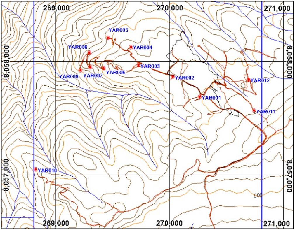
Figure 3: Location of the Rio Tinto RC holes from the 2000 program
To view an enhanced version of this graphic, please visit:
https://images.newsfilecorp.com/files/1134/262022_solis3.jpg
APPENDIX 2 - JORC Code, 2012 Edition - Table 1
| Criteria | JORC Code explanation | Commentary |
| Sampling techniques |
|
|
| Drilling techniques |
|
|
| Drill sample recovery |
|
|
| Logging |
|
|
| Sub-sampling techniques and sample preparation |
|
|
| Criteria | JORC Code explanation | Commentary |
| Quality of assay data and laboratory tests |
| All rock chips will be assayed by ALS in Lima. Methods intended to use:
|
| Verification of Sampling and assaying |
|
|
| Location of data points |
|
|
| Data spacing and distribution |
|
|
| Orientation of data in relation to geological structure |
|
|
| Criteria | JORC Code explanation | Commentary |
| Sample security |
|
|
| Audits or reviews |
|
|
Section 2 Reporting of Exploration Results
(Criteria listed in the preceding section also apply to this section)
| Criteria | JORC Code explanation | Commentary |
| Mineral tenement and land tenure status |
|
|
| Exploration done by other parties |
|
|
| Geology |
|
|
| Drill hole Information |
|
|
| Criteria | JORC Code explanation | Commentary |
| Data aggregation methods |
|
|
| Relationship between mineralisation widths and intercept lengths |
|
|
| Diagrams |
|
|
| Balanced reporting |
|
|
| Other substantive exploration data |
|
|
| Further work |
|
|
![]()
To view the source version of this press release, please visit https://www.newsfilecorp.com/release/262022
Tags
Michael Chen
Michael has over 15 years of experience covering junior mining companies, with a focus on precious metals exploration and development.
View All Articles →